Showing posts with label Europe. Show all posts

Thursday, October 29, 2020

Spanish farmer finds 3,000 years old lion sculpture while ploughing his olive grove


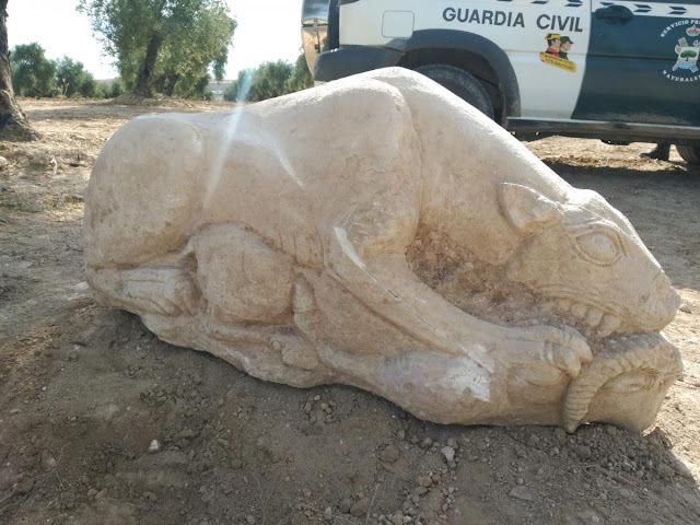
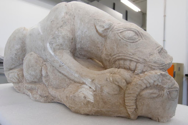
On a farm in Cañablanquilla, near San Sebastián de los Ballesteros (Córdoba, Spain), farmer Gonzalo Crespo was working in the family olive grove when his tractor hit what he thought was a large stone. When he stopped to inspect what it was he had hit, he was amazed to see a large statue of a lioness capturing her prey.


Spanish farmer finds 3,000 years old lion sculpture while ploughing his olive grove
Credit: Seprona


Immediately after the discovery, Crespo called the Civil Guard and members of the Seprona presented themselves together with other technicians  from the Delegation of Culture of the Junta de Andalucía. 


Spanish farmer finds 3,000 years old lion sculpture while ploughing his olive grove
Credit: AJ Gonzalez


The large sculpture is in perfect condition and according to archaeologists could be 3,000 years old. It was subsequently moved to the Archaeological Museum of Cordoba to be cleaned and examined. 


Spanish farmer finds 3,000 years old lion sculpture while ploughing his olive grove
Credit: AJ Gonzalez

According to Francisco Javier Maestro, mayor of San Sebastián de los Ballesteros, although there are documented vestiges of the Roman era in the municipality, this is the first time that an archaeological find of such importance has been made.


Source: Diario Cordoba [trsl. TANN, October 29, 2020]


Support The Archaeology News Network with a small donation!


The Mycenaean necropolis of Trapeza, Aegion, comes to light


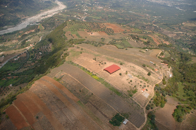
A large number of grave offerings and high-quality burial items were discovered during the five-year excavation programme at the Mycenaean necropolis of Trapeza, seven kilometers southwest of Aegion. The findings testify to the region’s amazing cultural and social vitality. The plateau is identified with the city of Rhypes, the metropolis of Croton in Magna Graecia during the colonization of the 8th century BC.


The Mycenaean necropolis of Trapeza, Aegion, comes to light
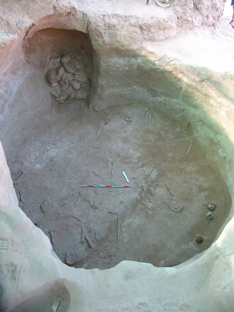
View of chamber of Tomb 1 [Credit: MOCAS]


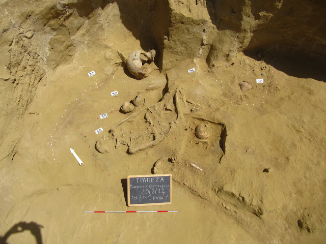
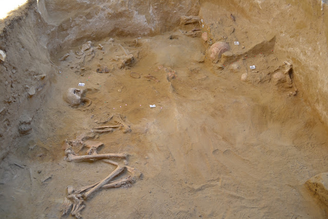
The Mycenaean necropolis is located on the southwestern slope of the plateau and on the ancient road leading to the citadel of historical times. The excavated tombs are arranged on at least three levels of terraces along the south side of Trapeza, a few meters from each other, in a parallel arrangement and with a north-south orientation. These are chamber tombs carved into the soft rock of the subsoil.


The Mycenaean necropolis of Trapeza, Aegion, comes to light
View of chamber of Tomb 7 [Credit: MOCAS]

The necropolis comprises tombs with chambers no wider than 3.5-4 meters and streets not exceeding a length of 6-7 meters and a width of 1.5 meters. The burial chambers have various shapes; circular, rectangular and even almost quadrangular with rounded corners and walls with irregular contours. Elongated pits were unearthed below the chambers, carved niches in the streets’ retaining walls for the secondary deposition of older burials, as well as elliptical or square pits dug in the street surfaces which were found to be empty and could have been originally been carved for concealing ritual ware. The side chambers in the streets of the tombs where children were buried are of particular importance.


The Mycenaean necropolis of Trapeza, Aegion, comes to light
View of Tomb 2 with the chamber’s entrance door [Credit: MOCAS]

The tombs were used repeatedly and over a long period of time. The tomb chambers collapsed in historical times, between the Geometric and Archaic period, as indicated by the artefacts found in “craters” formed in the ground owing to the collapse of the chambers’ roofs.


The Mycenaean necropolis of Trapeza, Aegion, comes to light
View of the archaeological site from the southwest [Credit: MOCAS]


The necropolis, founded in the LH IIIA 1 period, experienced its heyday during the Early Palatial period of the Mycenaean world, i.e. in parallel with the heights reached by the great centers of Mycenae, Tiryns and Pylos. A significant reuse of the tombs dates back to the 12th century BC, during the Post-Palatial period, probably after the early LH IIIC, when the tombs were repeatedly reopened, being at the same time a place of burial customs and complex ritual practices until the end of the Bronze Age, probably in the advanced Sub-Mycenaean period.


The Mycenaean necropolis of Trapeza, Aegion, comes to light
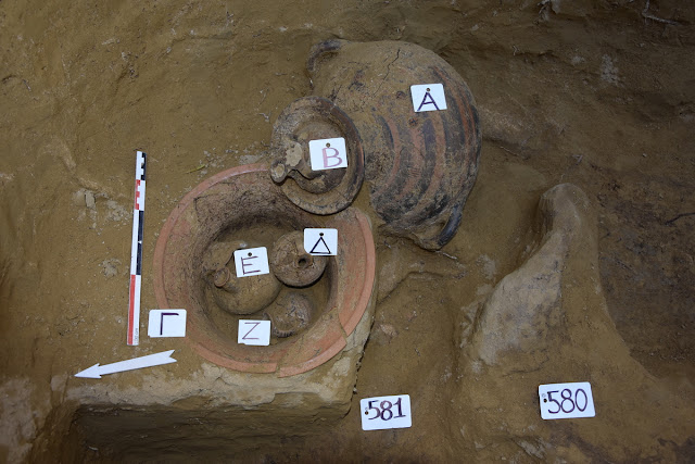
Assemblage of vessels from the Mycenean necropolis of Trapeza [Credit: MOCAS]

The quality of the finds of the Mycenaean necropolis of Trapeza is proved by the valuable sets of vessels that show a dependence on palace standards but also autonomous links with other regions, from the western Peloponnese to Crete. The grave goods are enriched with numerous seal stones and all kinds of beads and tesserae from various materials – glass, faience, gold, carnelian, rock crystal – that make up necklaces and ornate jewelry, ox head shaped gold-amulets indicating trading relations with the eastern Aegean and Cyprus.  A few tombs show elements of elitism, declaring social prestige and a possible connection with the palaces especially by a valuable combination of weapons and tools.


The Mycenaean necropolis of Trapeza, Aegion, comes to light
Assemblage of vessels from the chamber of Tomb 6 [Credit: MOCAS]

The Post-Palatial period from the 12th century BC.and after includes various phases of use, which impress mainly for their ritual practices. These relate to the treatment of the bones and remains of the former deceased, who are regarded as glorious ancestors and become the recipients of offerings. The purpose of these ceremonies is to create a genealogical bond by activating the memory of a past perceived as an integral part of the community.


The Mycenaean necropolis of Trapeza, Aegion, comes to light
Collected intact vessels from Tomb 2 [Credit: MOCAS]


Moreover, the findings from the backfills of the streets of tombs provide exclusive evidence of social practices that are a milestone in the conducting of a funeral, but also of rituals such as offerings and libations in front of the sealed chamber doors during posthumous visits to the tombs. Thus, the necropolis also becomes a place for transmitting traditions and a collective memory.


The Mycenaean necropolis of Trapeza, Aegion, comes to light
Bronze weapons from the chamber of Tomb 6 [Credit: MOCAS]

The location of the Mycenaean settlement of Trapeza is not yet clear. During the early cycle of use of the necropolis, the settlement was possibly situated on a hill, about 100 meters south of Trapeza. Today, research of a Middle Helladic settlement is in progress at this site, yielding sporadic evidence of Mycenaean pottery.


The Mycenaean necropolis of Trapeza, Aegion, comes to light
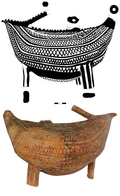
Bird shaped askos vessel [Credit: MOCAS]

The systematic excavation of Trapeza in Aigion, is headed by Dr. Andreas G. Bordos of the Ephorate of Antiquities of Achaia. Participating in the interdisciplinary research programme of the Mycenaean necropolis are Elisabetta Borgna, Professor of Aegean Archaeology at the University of Udine, with a group of students from the Universities of Udine, Trieste and Venice, as well as postgraduate students from Greek universities.


Source: Greek Ministry of Culture [trsl. Archaeology & Arts, October 29, 2020]


Support The Archaeology News Network with a small donation!


Wednesday, October 28, 2020

Grave of Viking woman found in central Norway


Norwegian University of Science and Technology (NTNU) field manager Eystein Østmo and a team of archaeologists have made a unique discovery which has puzzled archaeologists across the country.


Grave of Viking woman found in central Norway
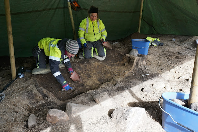
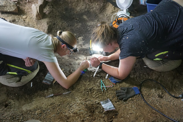
Maria Vestvik and Elise Kjørsvik from the NTNU Science Museum at the Viking grave
[Credit: Eystein Østmoe/NTNU University Museum]


Soil that was visibly black and greasy initially gave away the gravesite. This also gave away the site’s longevity. It pointed to the fact that a person had been buried underground her a long time ago. The grave has, in fact, been dated to around 1,000 years ago.


Grave of Viking woman found in central Norway
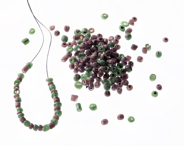
Some of the grave beads found [Credit: Åge Hojem/ 
NTNU University Museum]

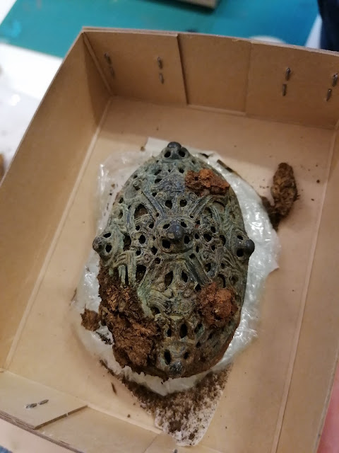
Archaeological finds of Viking graves aren’t necessarily unusual. This particular site, however, gave researchers a surprise. Graves are usually found in groups, but this was the only burial site for miles around. But that’s not all. Remains of a square encasement showed that this no ordinary grave. It was a burial chamber.


Grave of Viking woman found in central Norway
Ingvild Mjelde and Elise Kjørsvik clean the beads [Credit: Eystein Østmoe/
NTNU University Museum]


Such chambers were usually reserved for city folk and elite members of Viking society. But Hestnes in Trøndelag was a countryside location since the Viking Age, far from larger settlements.


Grave of Viking woman found in central Norway
The woman's buckle [Credit: Eystein Østmoe/
NTNU University Museum]

Grave items indicate that the woman was buried about a thousand years ago. Bone and teeth remains have been discovered in the grave. Once they’re analyzed further, they might give key clues as to who the Viking woman was.


Grave of Viking woman found in central Norway
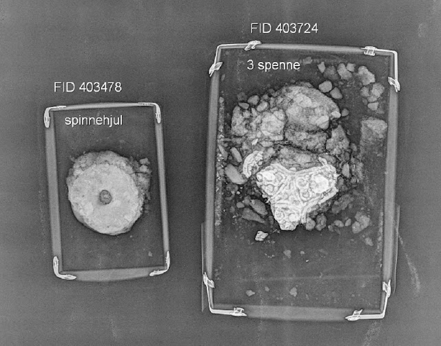
Finds from the grave. Spinning wheel and buckle [Credit: Thora Nyborg/
 NTNU Science Museum]


Green and purple-coloured beads are also among found artifacts. So far, researchers have counted over 300. Various brooches and combs were retrieved, too.


Grave of Viking woman found in central Norway
The excavation area at Hestnes [Credit: Kristoffer Rantala/
NTNU Science Museum]

Given the elaborate nature of the grave and items within, scientists believe the woman was among the more powerful members of the local community.


As of now, the mystery lady’s identity remains to be unravelled.


Source: Norway Today [October 28, 2020]


Support The Archaeology News Network with a small donation!


Bison engravings in Spanish caves reveal a common art culture across ancient Europe


Recently discovered rock art from caves in Northern Spain represents an artistic cultural style common across ancient Europe, but previously unknown from the Iberian Peninsula, according to a study published in the open-access journal PLOS ONE by Diego Garate of the Instituto Internacional de Investigaciones Prehistoricas de Cantabria, Spain, and colleagues.


Bison engravings in Spanish caves reveal a common art culture across ancient Europe
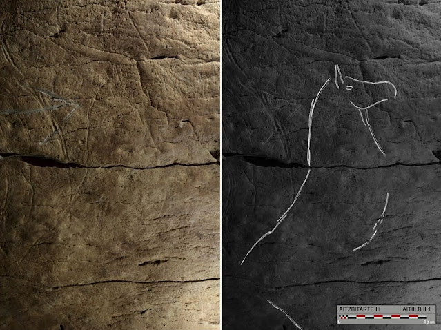
Photograph and tracing of horse B.II.1, engraved on the right-hand wall in Aitzbitarte
Cave III (O. Rivero and D. Garate) [Credit: Garate et al., 2020]

The history of ancient human art includes various cultural complexes characterized by different artistic styles and conventions. In 2015, new instances of rock art were discovered in three caves in Aitzbitarte Hill in northern Spain, representing an artistic style previously unknown from the Iberian Peninsula. In this study, Garate and colleagues compare this artistic style to others from across Europe.


The artwork in the Aitzbitarte caves consists mostly of engravings of bison, complete with the animals' characteristic horns and humps. The authors note the particular style in which the animals' horns and legs are drawn, typically without proper perspective. Pairs of limbs are consistently depicted as a "double Y" with both legs visible, and the horns are similarly draw side-by-side with a series of lines in between.


This is consistent with the artistic style of the Gravettian cultural complex, characterized by specific customs in art, tools, and burial practices between about 34,000 and 24,000 years ago. This culture is known from across Europe but has not been seen before on the Iberian Peninsula. The authors combine this new discovery with data from around Europe to show that the Gravettian culture was more widespread and varied than previously appreciated.


The authors add: "The study analyses the particularities of Palaeolithic animal engravings found in the Aitzbitarte Caves (Basque Country, Spain) in 2016. These prehistoric images, mainly depicting bison, were drawn in a way that has never before been seen in northern Spain; in a kind of fashion in the way of drawing the engravings that is more characteristic of southern France and some parts of the Mediterranean. The study has shown the close regional relationships in Western Europe cave art since very early times, at least, 25,000 years ago."


Source: Public Library of Science [October 28, 2020]


Support The Archaeology News Network with a small donation!


Tuesday, October 27, 2020

A novel method for illustrating stone tools


Until now, lithic illustrations have been hand-drawn by archaeological illustrators or researchers with extensive experience. In recent decades, however, lithic illustrations have been used less and less, owing to high-costs and the increased use of photography.


A novel method for illustrating stone tools
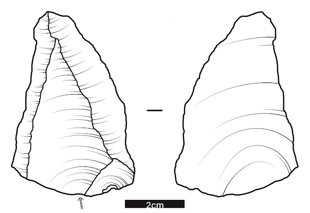
Finished illustration produced using the STIVA protocol
[Credit: © Jacopo Cerasoni]


But lithic illustrations are still an invaluable tool for archaeology which cannot be substituted with photographs or any other recording method present today. With this newly optimized step-by-step protocol, Jacopo Cerasoni of the ‘Lise Meitner’ Pan-African Evolution research group at the Max Planck Institute for the Science of Human History offers a novel method for illustrating stone tools, giving everyone - from professional researchers to students - the possibility to produce cost-free, competent and publishable illustrations.


Access the protocol here.


Source: Max-Planck-Gesellschaft [October 27, 2020]


Support The Archaeology News Network with a small donation!


Monday, October 26, 2020

Maritime archaeologist finds four ‘lost’ Dutch medieval villages


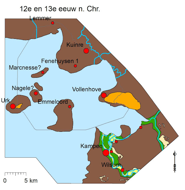
A study of the north-eastern part of the Noordoostpolder – an area of reclaimed land north east of Amsterdam – has yielded the approximate locations of four lost medieval peat islands. Sources from the early Middle Ages mention four settlements thought to have originated in the 10th and 11th centuries when people started to farm what was then an area of peat soil. 


Maritime archaeologist finds four ‘lost’ Dutch medieval villages
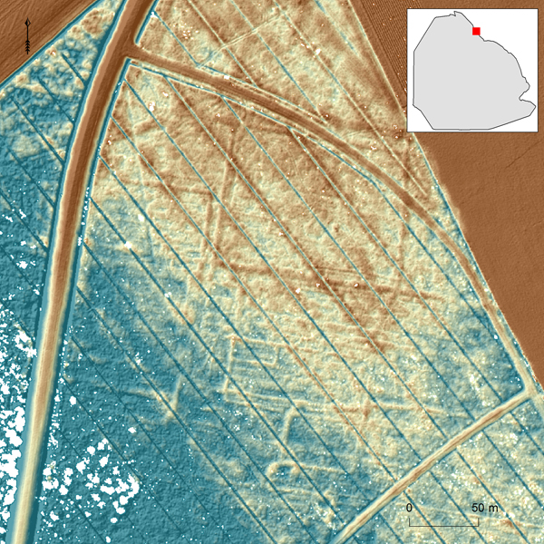
A dense network of linear structures is visible on the LiDAR data of the Kuinder Forest surface.
The northwest-southeast oriented blue lines are modern drainage ditches (blue is low,
red is high) [Credit: Institute of Archaeology, University of Groningen]

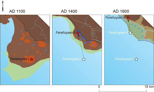
So far it was never clear where these might have been. In the late Middle Ages part of the area now known as the Noordoostpolder was flooded and the inland sea Zuiderzee was formed, swallowing up the four ‘drowned’ villages of Marcnesse, Nagele, Fenehuysen I and Feneguysen II. 


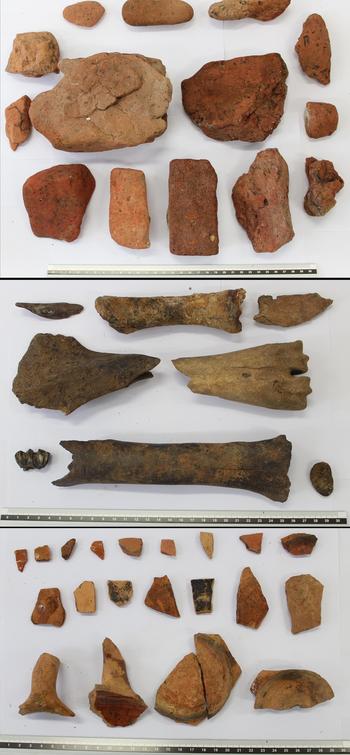
Maritime archaeologist Yftinus van Popta started his five year search by charting all the archaeological objects found in the Noordpoostpolder. Until then it was thought that the finds –  bricks, roof tiles, bones and earthenware – had fallen off passing ships. But to Van Popta the objects signified human habitation. 


Maritime archaeologist finds four ‘lost’ Dutch medieval villages
Archaeological remains that were found in the submerged village
of Veenhuizen: bricks, earthenware and animal bone material
[Credit: Institute of Archaeology, University of Groningen]

"Bricks are remnants of houses, the bones came from the meat people ate and the earthenware shards came from cooking pots," Van Popta told broadcaster Nos. Moreover, shipping in the area did not come about until later. "These objects ended up in the ground between 1100 and 1300 AD. The first ships did not sail there until 1250 to 1300 AD," he said. 


Further digging based on satellite imaging showing evidence of human activity, such as ditches also revealed that the concentrations of comparable finds of bricks, shards and bones were similar to that of surviving peat island settlements like Urk and Schokland. 


Maritime archaeologist finds four ‘lost’ Dutch medieval villages
Reconstruction of the Noordoostpolder area around 1100 to 1200 AD
[Credit: Institute of Archaeology, University of Groningen]

Maps Pinpointing the exact location of the lost villages is difficult because possible remnants in the soil have severely deteriorated. Further investigation of old maps and historical sources may help Van Popta to start a more focused search for more evidence, such as pits and foundations. 


Thanks to the efforts of Van Popta, who recently completed his PhD, the area now has protected status. Any building work in the area will be subject to prior archaeological investigation and ploughing is restricted to a depth of 30 centimetres. 


Maritime archaeologist finds four ‘lost’ Dutch medieval villages
Reconstruction of the shifting nature of Fenehuysen. Brown: peatland; green: drowned peatland;
orange: settlement remains: blue: water; grey: dikes  [Credit: Institute of Archaeology,
University of Groningen]

"We have found a lost piece of the Netherlands. I was convinced it was there but then you have to prove it. It’s nice to know I haven’t spent five years working for nothing," Van Popta told the broadcaster.


Source: Dutch News [October 26, 2020]


Support The Archaeology News Network with a small donation!


2020 results of the Ancient Tenea research program at Chiliomodi, Corinth


In October 2020, the 'Ancient Tenea' research work at Chiliomodi, Corinth, under the direction of  Dr. Elenas Korka was completed.
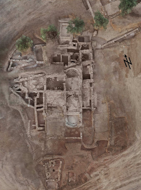

2020 results of the Ancient Tenea research program at Chiliomodi, Corinth
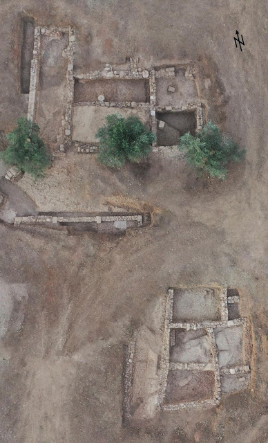
Aerial view of the excavation site of ‘Ancient Tenea’ in Chiliomodi, Corinth
[Credit: Greek Ministry of Culture, Tenea Project 2020]


The excavations continued in the area of the bath complex that was located in 2019. To the west, the water supply for the baths were discovered. In the south, the excavation of the 'changing rooms' was completed, with a total area of 62 sq.m. The entire area is covered by clay floor slabs and stone built benches around its walls. The changing rooms to the east communicate with two new rooms that are identified with the tepidarium. One of them is a pool of 20 sq.m., and the second has on its floor structures that suggest the existence of baths.

2020 results of the Ancient Tenea research program at Chiliomodi, Corinth
Aerial view of the excavation site of ‘Ancient Tenea’ in Chiliomodi, Corinth 
[Credit: Greek Ministry of Culture, Tenea Project 2020]

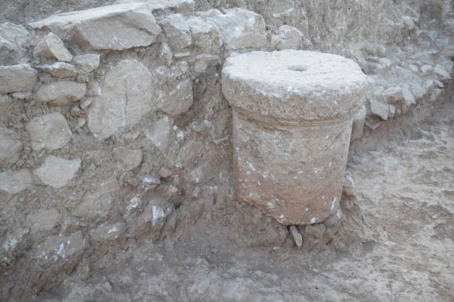
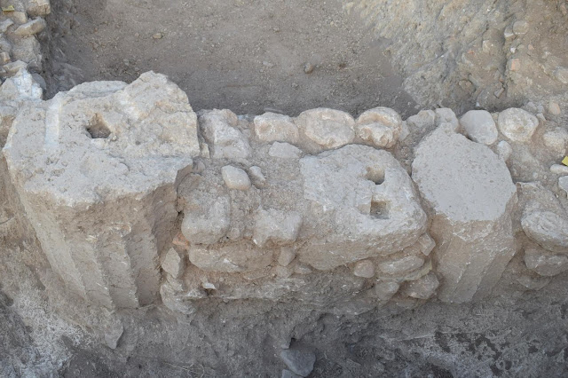
The bath complex seems to have been originally built in the time of Augustus with interventions and reconstructions until the late Roman times. However, its northern part may have been built on an Archaic wall associated with the use of the well investigated in 2019. An archaic deposit investigated this year north of the well yielded pottery, a bronze ring, bronze and bone fibulae, and an animal-shaped figurine. In the northwestern part of the facility, retaining walls were discovered, built largely with archaic spolia, a practice that applies to the entire monument. These architectural elements included triglyphs, entablatures, cornices, columns and two parts of ribbed columns with a diameter of 0.74m and indicate the existence of large public buildings of the Archaic period in the vicinity of the baths. Finally, north of the bath complex a new pool measuring 8.5 sq.m. was unearthed, with a floor of clay slabs covered with mortar and stone built benches along its eastern wall.

2020 results of the Ancient Tenea research program at Chiliomodi, Corinth
Architectural pieces in secondary use [Credit: Greek Ministry of Culture, 
Tenea Project 2020]

2020 results of the Ancient Tenea research program at Chiliomodi, Corinth
Architectural pieces in secondary use [Credit: Greek Ministry of Culture,
Tenea Project 2020]


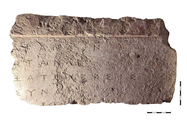
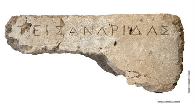
Two inscriptions were also discovered built into the walls of the bathing room. The first appears to be part of a public inscription with a painted cornice, and was found together with a silver obol from Argos dating to the beginning of the 5th century BC. The second inscription was on a statue base dating to fourth century BC. It bears the name ΠΕΙΣΑΝΔΡΙΔΑΣ (PEISANDRIDAS) and is of particular importance, as it is the first strong indication of the connection of Tenea with Tenedos, as indicated by ancient literary sources. The poet Pindar, for example, mentions Peisandros as the ancestor of the hegemonic family of Tenedos, the Peisandrids.

2020 results of the Ancient Tenea research program at Chiliomodi, Corinth
Inscription on a stone base of a bronze statue, fourth century BC
[Credit: Greek Ministry of Culture, Tenea Project 2020]

2020 results of the Ancient Tenea research program at Chiliomodi, Corinth
Part of a public inscription, fifth century BC [Credit: Greek Ministry of Culture,
Tenea Project 2020]

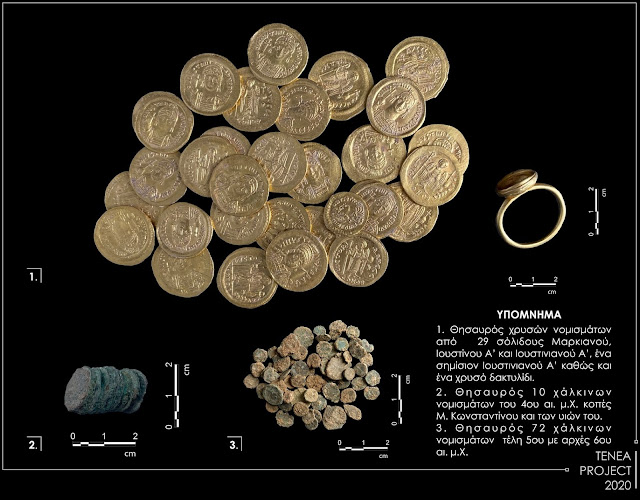
The baths currently cover an area of 875 sq.m. even though the frigidarium has yet to be located. The size of the complex is an additional element that confirms their public use. Among other things, two small coin hoards were found in the baths, dating to the 4th and 5th centuries AD.

2020 results of the Ancient Tenea research program at Chiliomodi, Corinth
i) Hoard of 29 gold coins of Marcian, Justin I and Justinian; ii) Hoard of 10 bronze coins of the fourth
 century AD; iii) Hoard of 72 coins from the end of the fifth and start of the sixth centuries AD
[Credit: Greek Ministry of Culture, Tenea Project 2020]

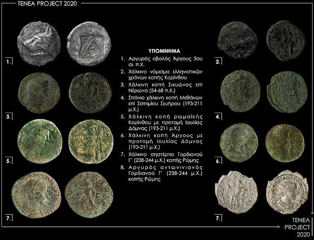
2020 results of the Ancient Tenea research program at Chiliomodi, Corinth
i) Argive obol of the fifth century BC; ii) bronze coin of the Hellenistic period; iii) bronze coin of Sikyon
from the reign of Nero (AD 68-54); iv) rare bronze coin from Methana in the rain of Septimius
Severus (AD 193-211); v) bronze coin from Roman Corinth with the face of Julia Domna
(AD 193-211); vi) bronze coin of Argos with face of Julia Domna (AD 193-211); vii) bronze
 issue of Gordion III (AD 238-244); viii) bronze issue of Gordion III (AD 238-244)
[Credit: Greek Ministry of Culture, Tenea Project 2020]


In the eastern area under investigation, extensive building foundations (282 sq.m.) were found in a north-south layout, which are identified with areas of commercial activity. These areas are connected to the baths via a cobbled road. Objects of commercial activity were found here: inscribed bronze scales, millstones, glass and ceramic vessels, a bronze pin, jewellery, iron objects such as forks, buckles, plates, and nails, a spear, a stone inscription, a clay inscription and over 300 coins. 72 bronze coins of the 5th century AD., and 29 coins of the emperors Marcian, Justin I and Justinian (AD 450 AD to AD 565), were found here, as well as a gold ring. In total, this year's excavation found more than 400 coins from different periods of antiquity.
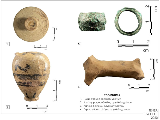

2020 results of the Ancient Tenea research program at Chiliomodi, Corinth
i) Clay pyxis of the archaic period; ii) coarse aryballos of the archaic period; iii) bronze
ring of the archaic period; iv) clay figurine of the archaic period
[Credit: Greek Ministry of Culture, Tenea Project 2020]

In the area between the bath and the commercial premises, sections of walls which likely belong to yet another public space were revealed. This area will be systematically explored at a later time. Finally, a workshop area (47 sq.m.) relating to iron processing, was located south of the baths. 
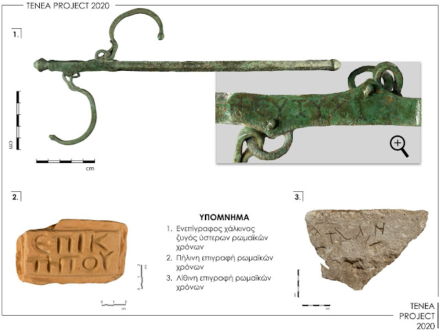

2020 results of the Ancient Tenea research program at Chiliomodi, Corinth
i) Bronze buckle of the Roman period; ii) clay inscription of the Roman period; iii) stone inscription
of the Roman period [Credit: Greek Ministry of Culture, Tenea Project 2020]

The finds from the excavation indicate that the area was used continually from the 6th century BC until the 6th century AD. The numerous luxurious buildings and public facilities reveal the long settlement history of Tenea. Above all, the abundance of important architectural members from public buildings of the Archaic period that are incorporated into the masonry of Roman buildings is likewise remarkable.
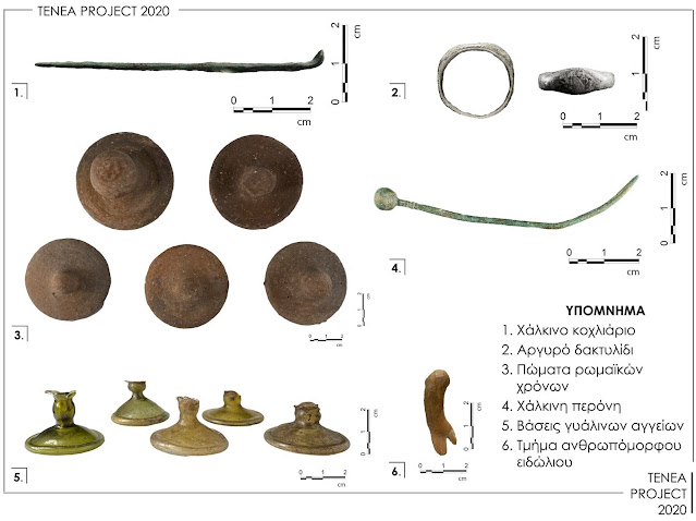

2020 results of the Ancient Tenea research program at Chiliomodi, Corinth
i) Bronze pin; ii) Argive ring; iii) Roman period stoppers; iv) Bronze pin; v) bases of glass vessels;
vi) piece of humanoid figurine [Credit: Greek Ministry of Culture, Tenea Project 2020]

The program, under the direction of Dr. E. Korka, is supported by an interdisciplinary team of archaeologists headed by Mrs. P. Evangeloglou from the Ephorate of Corinth, as well as numismatists, anthropologists, surveying engineers, geologists and students from University Institutions of Greece. In the context of the above collaborations, modern methods of photogrammetric imaging, three-dimensional display of archaeological objects and anthropological material, as well as geophysical surveys were applied.


Source: Greek Ministry of Culture [trsl. TANN, October 26, 2020]


Support The Archaeology News Network with a small donation!